


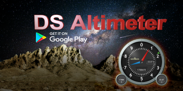
Altimeter & Altitude Widget


توضیحات Altimeter & Altitude Widget
DS Altimeter is an elevation meter, elevation logger, and altitude mapper. In addition to showing and optionally tracking your altitude, the app allows you to search the altitude for other locations as well.
You can select from the best sources of elevation data, including:
1. Location based altitude from NASA's Shuttle Radar Topography Mission.
2. Satellite based altitude (GPS altitude) corrected to height above mean sea level (AMSL).
3. Get actual land survey altitude values for your location from the United States Geologic Survey - available for customers in the contiguous United States, southern Canada and Mexico.
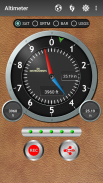
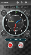
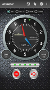
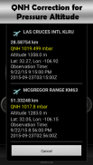
4. Devices equipped with a barometer sensor can also obtain pressure altitude which is converted to elevation above sea level. For the most precise readings, calibrate the pressure altitude.
The barometric altimeter offers 4 calibration tools:
1. Calibrate to the nearest airport. Choose your airport from the app's dynamic list of nearest airfields. Airfield data is usually updated every 20 - 30 minutes.
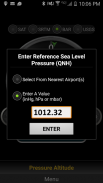
2. Enter a QNH value.
3. Enter the benchmark (known) altitude value for your location.
4. Calibrate the barometric altimeter against the SRTM altitude map.
DS Altimeter also works offline: barometric altitude and GPS altitude corrected to elevation above sea level do not require an internet connection.
NEW IN DS ALTIMETER:
● Photo altimeter. Snap a picture of your favorite high places with the altitude shown on your photograph.
● Easily get the altitude difference and grade between two locations by tapping 2 points on a map.
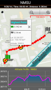
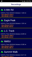
● Record altitude profiles and elevation tracks for your favorite journeys to the highlands, the lowlands and everything in-between!
● [SPECIAL] View your altitude recordings on the included maps with all track points displayed. Tap any track point and get the altitude at that point.
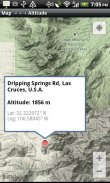
● Elevation Search: Enter a place name or address and get the altitude above sea level at that location.
Upgrade the application to pro and gain access to even more features including the Altimeter Widget.
Going skiing? Record your ski run with DS Altimeter, then view your ski trail with its elevation points on the included maps. Mininum and maximum altitude points for your run will be clearly shown.
Altitude mapping and bathymetry (lake and sea depths) are also included with DS Altimeter. Tap anywhere on a map to find altitude or water depth at that location.
● The application includes a detailed help section.
* The perfect altimeter for skiing, hiking, mountain climbing and other outdoor sports, boating, marine navigation and anytime you are curious about your elevation!
PERMISSIONS AND PRIVACY:
DS Software does not collect any personal information such as phone ID or user account information.
1. Location permission if required for GPS. GPS data is used for land survey altitude matching and to determine elevation above the Geoid (then corrected to elevation above sea level).
2. Photos/Media/Files permission is required for the screen capture procedure allowing you to share an image of your altitude result.
3. Wake-up phone (Wake-Lock) and Boot Permission are required to periodically refresh the values on the Altimeter Widget and to reactivate the Altimeter Widget when the phone is rebooted / restarted.
4. Internet and Network permissions are needed to access online land survey databases in Government facilities.
5. Billing permission is required to purchase the application for the purpose of activating the altimeter widget, remove advertising and to receive unlimited altitude-track recordings.
6. Vibrate permission - to vibrate the phone for important alerts.
ارتفاع سنج DS ارتفاع سنج، ارتفاع سنج و نقشه گیر ارتفاع است. علاوه بر نشان دادن و به طور اختیاری ردیابی ارتفاع شما، برنامه اجازه می دهد تا شما را به جستجو در ارتفاع برای مکان های دیگر نیز هست.
شما می توانید از بهترین منابع ارتفاع داده ها انتخاب کنید، از جمله:
1. ارتفاع موقعیت مکانی از ماموریت توپوگرافی راداری شاتل ناسا .
2. ارتفاع ماهواره ای (ارتفاع GPS) به ارتفاع بالاتر از سطح دریا (AMSL) اصلاح شده است .
3. دریافت مقادیر ارتفاع سنجی واقعی زمین برای مکان خود را از بررسی جغرافیایی ایالات متحده - در دسترس برای مشتریان در ایالات متحده، جنوب کانادا و مکزیک مجاور .
4. دستگاه های مجهز به سنسور فشارسنج همچنین می توانند سطح فشار را به ارتفاع بالاتر از سطح دریا تبدیل کنند. برای دقیق ترین قرائت ها، ارتفاع فشار را کالیبره کنید .
ارتفاع سنج سنجی دارای 4 ابزار کالیبراسیون است:
1. به نزدیک ترین فرودگاه کالیبره کنید. فرودگاه خود را از فهرست دینامیکی برنامه نزدیکترین فرودگاه ها انتخاب کنید. داده های هواپیما معمولا هر 20 تا 30 دقیقه به روز می شود.
2. مقدار QNH را وارد کنید.
3. مقدار ارتفاع معیار (شناخته شده) برای مکان خود را وارد کنید.
4. ارتفاع سنج فشار سنج علیه نقشه ارتفاع SRTM را تنظیم کنید.
ارتفاع سنج دیجیتال نیز به صورت آفلاین کار می کند: ارتفاع سنجی و ارتفاع GPS که به ارتفاع بالاتر از سطح دریا اصلاح شده است نیاز به اتصال به اینترنت ندارند.
جدید در DS آلتیمتر:
● ارتفاع سنج عکس یک عکس از مکان های مورد علاقه خود را با ارتفاع بالا نشان داده شده در عکس خود ضربه بزنید.
● به راحتی تفاوت ارتفاع و درجه بین دو مکان را با ضربه زدن به 2 امتیاز بر روی نقشه دریافت کنید.
● پروفایل های ارتفاع ارتفاع و آهنگ های ارتفاع برای سفرهای مورد علاقه خود را به مناطق مرتفع، دهنه و همه چیز در میان را ثبت کنید!
● [ویژه] ضبط های ارتفاع خود را در نقشه های گنجانده شده مشاهده کنید با تمام نقاط مسیر نمایش داده شده. هر نقطه مسیر را ضربه بزنید و ارتفاع را در آن نقطه دریافت کنید.
● جستجوی ارتفاع: نام محل یا آدرس را وارد کنید و ارتفاع آن را از سطح دریا در آن محل دریافت کنید.
نرم افزار را به نرم افزار ارتقا دهید و به ویژگی های حتی بیشتر از جمله ویجت ارتفاع سنج دسترسی پیدا کنید.
رفتن اسکی؟ رانندگی اسکی خود را با DS Altimeter ضبط کنید، سپس مسیر پیاده اسکیت خود را با امتیازات ارتفاع آن در نقشه های موجود مشاهده کنید. حداقل و حداکثر امتیازات ارتفاع برای اجرای شما به وضوح نشان داده خواهد شد.
نقشه کوهستانی و باتیمتری (دریاچه و عمق دریا) نیز با DS Altimeter گنجانده شده است. برای پیدا کردن ارتفاع یا عمق آب در آن مکان، روی نقشه کلیک کنید.
● برنامه شامل یک بخش کمک مفصل است.
* ارتفاع سنج عالی برای اسکی، پیاده روی، کوه نوردی و دیگر ورزش های فضای باز، قایقرانی، ناوبری دریایی و هر زمان که شما در مورد ارتفاع خود کنجکاو هستید!
مجوزها و حفظ حریم خصوصی:
DS Software اطلاعات شخصی مانند شناسه تلفن یا اطلاعات حساب کاربری کاربر را ذخیره نمی کند.
1. اگر نیاز به GPS دارید، مجوز محل سکونت را انتخاب کنید. داده های GPS برای تطبیق ارتفاع سنجی زمین و برای تعیین ارتفاع بالاتر از Geoid (سپس به ارتفاع بالاتر از سطح دریا اصلاح می شود) استفاده می شود.
2. برای انجام روش ضبط صفحه نمایش، عکس / رسانه / فایل مورد نیاز است که به شما اجازه می دهد یک تصویر از نتیجه ارتفاع خود را به اشتراک بگذارید.
3. تلفن بیدار شدن از خواب (Wake-Lock) و بوت مجوز لازم است که به طور مرتب مقداردهی عناصر Altimeter را تازه سازی کنید و برای فعال کردن ویجت Altimeter هنگامی که گوشی راه اندازی مجدد / راه اندازی مجدد شود.
4. مجوز های اینترنت و شبکه برای دسترسی به پایگاه داده های آنلاین تحقیق زمین در امکانات دولتی مورد نیاز است.
5. برای خرید برنامه با هدف فعال کردن ویجت ارتفاع سنج، تبلیغ مجدد و دریافت ثبت نام ارتفاع بدون محدودیت، مجوز صدور صورتحساب لازم است.
6. لرزش اجازه - برای ارتعاش تلفن برای هشدار مهم است.
Altimeter & Altitude Widget - نسخه 4.62
(03-11-2023)

Altimeter & Altitude Widget - اطلاعات APK
نسخه APK: 4.62حزمة: com.discipleskies.android.altimeterآخرین نسخه Altimeter & Altitude Widget
سایر نسخهها


اپلیکیشنها در دسته مشابه


شاید دوست داشته باشید...


